Wednesday, May 28, 2008
Pearisburg, VA
May 15 and 16
Another small, poor Appalachia town. The people were very helpful and friendly however. I was able to arrange a slack pack shuttle with the owner of the Rendevous Motel. This gave me a 21.7 mile jump on the 93 mile stretch from Pearisburg to Daleville/Troutdale. It was also my first official 20+ mile day on the trail!
By doing this I was able to cut a 7 day leg down to a 5 day leg – much better.
May 17 and 18
1st day out of Pearisburg featured two tough climbs of 1,500+ feet of elevation gain. But it was a nice sunny day and my energy was good, so I knocked it out even though it took me nearly 11 hours to do the 16 miles carrying 5 days of supplies.
2nd day out of Pearisburg was only 12.4 miles, but in many ways a harder day. It rained all day long, was cold too. Temperatures were around 50 degrees. And windy to boot! A truly miserable day weather wise. Also had to cross some very treacherous cliffs in the afternoon that were very scary in the wet weather. I was very happy to get to camp in one piece tonight!
May 19
Did a short 10.1 miles today. Enjoyed the day very much. Observed two deer grazing by the trail for about 15 minutes. They watched me, I watched them – it was cool! I also saw my first rhododendrons in bloom today – also very cool. Nice weather today. Sunny.
Oh – had a very awesome thunderstorm last night that lit up the sky, rocked the mountains, and boomed the shelter. Very cool show to observe from a warm, dry shelter. Even better was the full moon that came out later in the night when the storm passed.
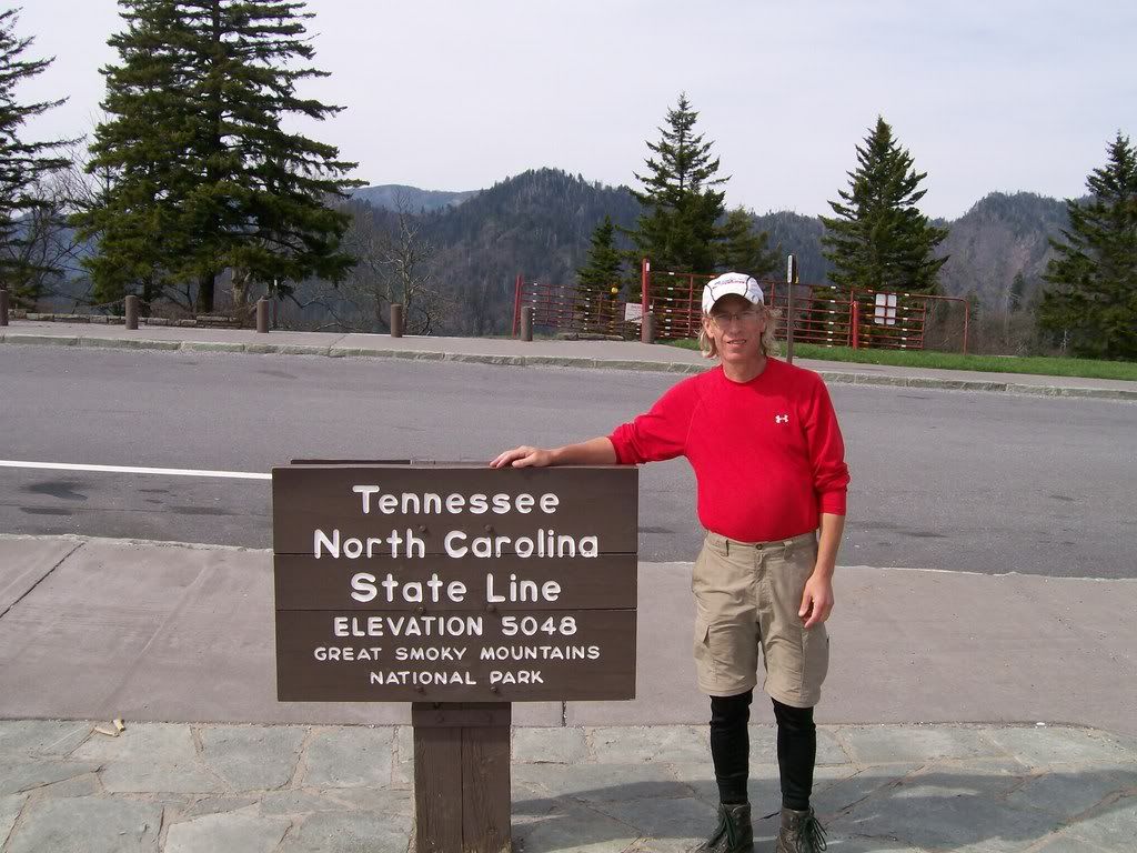
Bland, VA to Pearisburg, VA
May 12-15
Really not much to report here. Scenery was so-so. Weather was so-so. Most interesting thing was I found myself in a pack of about 20 northbound thru-hikers all headed for Pearisburg at the same time. We’d gotten bunched together by a sever storm that caused almost everyone to take a zero day at the same time in Bland (when I was there with Jen and Evie). We then were all on the same 2 ½ day plan to get to Pearisburg. It was a fun group of people, most of whom I’d met along the way before, so I enjoyed traveling for a few days with a large “herd”.
Really not much to report here. Scenery was so-so. Weather was so-so. Most interesting thing was I found myself in a pack of about 20 northbound thru-hikers all headed for Pearisburg at the same time. We’d gotten bunched together by a sever storm that caused almost everyone to take a zero day at the same time in Bland (when I was there with Jen and Evie). We then were all on the same 2 ½ day plan to get to Pearisburg. It was a fun group of people, most of whom I’d met along the way before, so I enjoyed traveling for a few days with a large “herd”.
The Big Visit
11 & 12 May
Had a wonderful visit with my daughter, Jennifer, and my Granddaughter, Evelyn. What a special treat! We had dinner at Ruby Tuesday and went shopping for various supplies I needed at WalMart.
Evelyn talks much more than when I left, though much of what she says is in Evie-speak that only she understands. I love her so much! She walks much better than she did 2 months ago and also has many more teeth. Otherwise, she is the same beautiful golden child I left at Neel’s Gap. She cried when I said goodbye, and it broke my heart – again.
Oh well – this time it will be less than a month until I see her and Jen (and my wife) again.
Friday, May 16, 2008
Rural Retreat to Bland, Virginia
May 8-11, 2008
Total Miles: 579.2
Not much special about this 45 mile section of the trail. I took a zero day at the Relax Inn in Rural Retreat due to severe thunderstorms, but since I’d allowed four days for this section, it did not hurt my schedule. I knocked it out in 3 days of 14, 19, and 12 miles. Walked thru a couple of pretty farms, but otherwise, a boring walk. Due to the storm and the limited shelters, plus the threat of more severe weather, a large bunch of us thru-hikers ended up in a cluster of about 20 hikers for these three days. I was very excited about the upcoming visit with my daughter and granddaughter of course.
Damascus to Rural Retreat, VA
May 4-7 2008
Total Miles: Over 500 Miles
This stretch included climbing over Mt. Rogers (highest point in Virginia) and crossing the Grayson Highlands. Wow? What awesome scenery in this section. It was like being on the set of an old TV show like “The Big Valley” or “Bonanza”. Wild ponies roaming the range, beautiful green pastures with cows and bulls grazing, flowers, and flowering trees blooming. In more than one place, I stood and just slowly rotated, clicking picture after picture, in an attempt to try to capture the 360 degree magnificence of the landscape.
This is the country side that inspired songs like, “America the Beautiful” and “This Land is My Land”.
My words cannot do it justice. I hope the photo’s help. Certainly the weather Gods were with me this week providing 70+ degree sunny skies to match the perfection of the landscape.
Along the way, I took a 2 mile road walk detour into Troutdale, VA where I dined for dinner and breakfast the next morning at Jerry’s Kitchen and spent the night as the guest of the Troutdale Baptist Church Hiker Hostel, which was also arranged by Jerry. Jerry is a really sweet guy, in his 40’s I’d guess. Likely works seven days a week at his family restaurant/grocery store in tiny Troutdale. I suspect he dreams of one day being free to hike the A.T. I hope his dream comes true.
The following night was spent at the “Partnership Shelter” also known as the “Pizza Shelter” because it is collocated with the Mt. Rogers National Recreation Area Headquarters on a major road and local pizza places and other restaurants will deliver fool there.
Well, me and four other hikers had a major feast from the Tuscany Grill that night. I won’t go into all the details, but will say I spent $27 just on my portion and could barely crawl into my sleeping bag when I got done!
I also met another hiker named “August” – a 17 year Army vet – who had brought a small chess set as his luxury item. I won 3 our of 4 games with him, though all four games were closely contested.
On May 7, I rolled into the (tongue-in-cheek) 5 star Relax Inn in Rural Retreat where I would resupply and rest up for next leg of my journey.
Damascus, Virginia
May 2-3
The so-called “Friendliest Town on the Trail” and the home of the largest annual hiking festival “Trail Days” held med-May each hear. People have been talking about Damascus for weeks. Being the contrarian that I am, I’ve been lowering my expectations consistent with everyone else raising theirs. I was not disappointed. Damascus is a little bigger than Hot Springs, but otherwise similar. The A.T. runs right thru the middle of town. It has all the usual hiker stuff: hostels, B&B’s, outfitters (multiple in this case), a bank, a few places to eat, a Laundromat, a Post Office, and a Dollar General store.
I, however, found that Damascus had a harder edge, was a bit dirtier, and lacked some of the charm and naiveté of Hot Springs. Perhaps the success of the “Trail Days” experience has ruined the small town feel of Damascus that once was. In any case, I walked into town about 12 noon on a sunny Friday. The town was bursting with hikers and tourists. I was fortunate to get one of the last available beds in the whole town. I had to take two nights, given that it was the weekend. So, I ended up at the truly lovely “Victorian Inn”, a B&B in a restored 1906 home. The innkeepers were retired antique dealers from Phoenix, so the house was jammed with awesome Eastlake antiques. I felt like I was back in Woodruff Place!
With my extra day in Damascus, I did an 18+ mile slack pack, which allowed me to finally get totally back on schedule. I’d been 1-2 days behind ever since my first zero day at Fontana Dam.
Oh, Mrs. B&B made some great breakfast treats as well, so my committed effort to stop losing any more weight is starting to work. Putting weight back on while hiking the trail is not likely possible – but, I think if I really stuff myself in town at every opportunity, I can at least stop the downward trend. Then I hope to gain maybe 5 pounds or so during the two weeks I’m off trail in June. Other than the weight loss, I’m doing fine physically.
Oh sure, I have aches and pains every day. My knees hurt every night as I go to sleep – but not enough to keep me awake. My shoulders scream at me every afternoon starting at about 2 p.m. from the pack straps cutting into me. But, almost miraculously, I have not had a single blister, and my feet rarely, if ever, hurt at all. So, I am in much better shape physically than many other who are hobbling along beside me. And, I am very grateful for that!
Dennis Cove Road (Kincora Hostel) to Damascus, VA
April 29- May 2, 2008
I spent 2 nights at the Kincora Hostel. The guy that runs it is truly a trail angel. It’s run strictly on donations – suggested $4.00 per night, when the for profit hostels all charge $15.00 per night – and he gives free shuttles to town twice a day, plus free slack pack shuttles, provides laundry soap, shampoo, TP, razors, you name it!
In a supreme example of how life is unfair, I heard from another hiker that his wife has a terminal illness for which there is no cure. People said it was quite unusual that she spent so little time out in the hostel with us. The God and Goddess must have very special plans for Pat in her next reincarnation, I just hope that her husband somehow gets to join her too.
Speaking of Karma – on my last morning at Kincora, Miss Willow was just arriving. You remember her – she was one of the four that survived the bear attack with me and that later tormented me for snoring in another shelter causing me to get so mad I broke contact with her and hiked away. Well – completely unsolicited by me, Willow sincerely apologized from the heart for poking me repeatedly that night and expressed remorse. She said she was sorry and hoped that it had not broken our friendship. I told her I was very glad that she apologized because it really did bother me a lot being poked and jabbed when trying to sleep. I accepted her apology and said that of course we were still friends.
I fell much better about this now because the last thing I came out on the trail to do was to make enemies. Rather, I hope to find friends!
The hike to Damascus was otherwise uneventful.
Friday, May 9, 2008
Short Slack-Pack Day
April 29, 2008
Slack packed nine miles from US Hwy 321 south back to Dennis Cove Road and the Kincora Hostel. The advantages of this short day were:
1. Allowed me to spend the night at Kincora when the outside temp was going to drop into the low 30’s or upper 20’s (brrrr!!)
2. Allowed me to go over a nearly 2,000’ mountain climb carrying 6 lbs instead of 35 lbs.
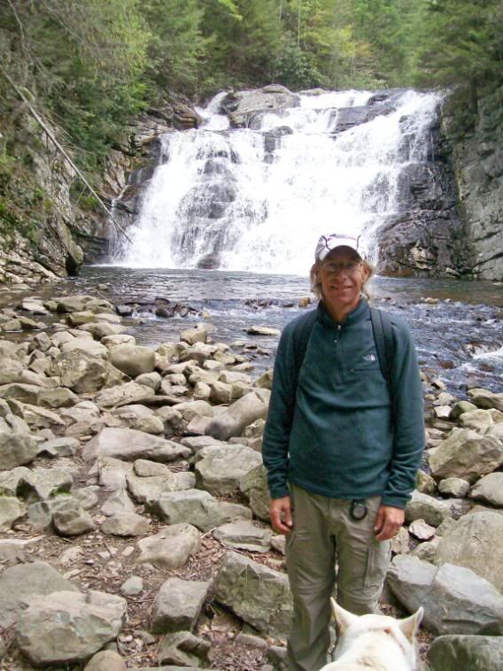
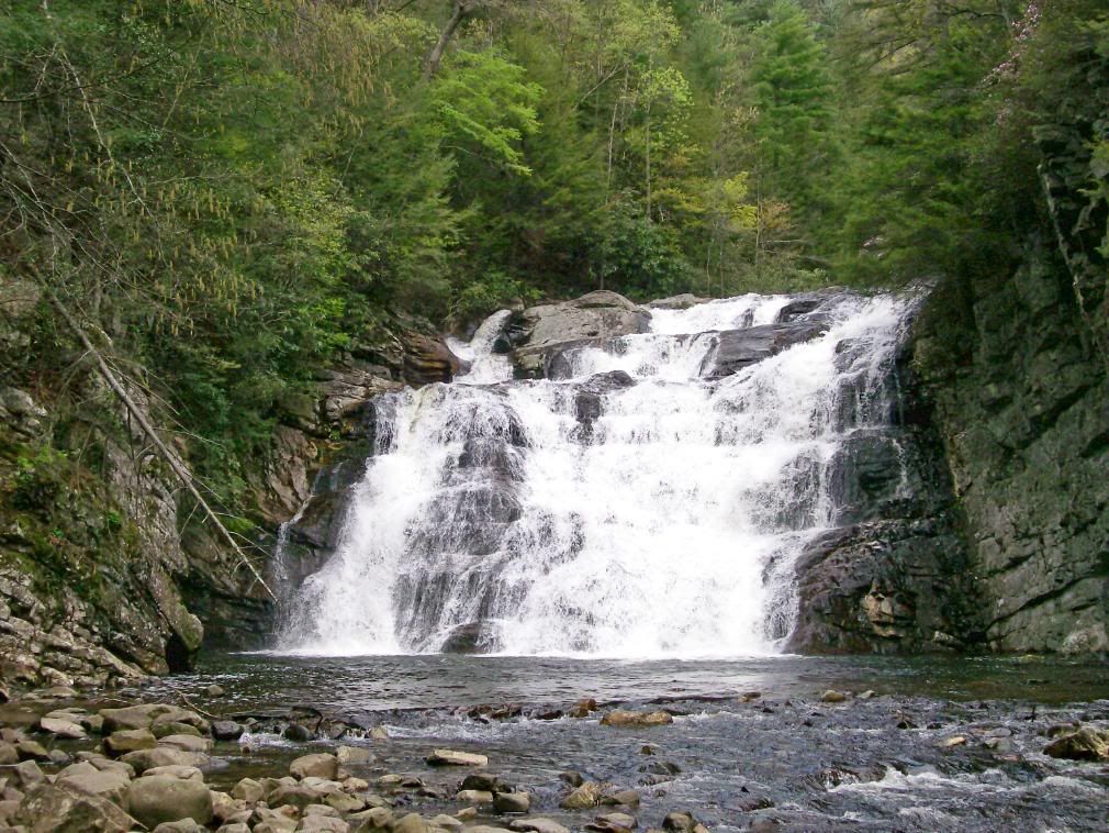
3. Allowed me to truly enjoy a spectacular waterfall at Laurel Falls. Laurel Falls – you must see the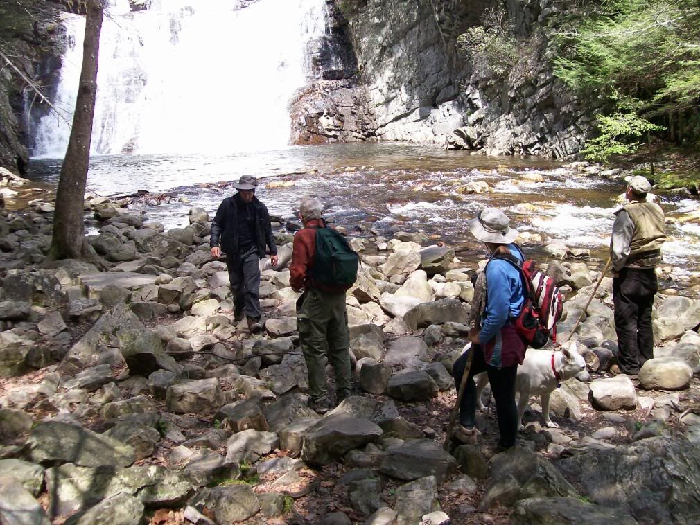 pictures – it is about 70’ tall and at least as wide. After three days of rain, the falls were nothing but raging white water – beautiful. Like Niagara Falls in miniature. Spent the afternoon, most of it anyway sitting around the hostel smokin’ and jokin’ with the other hikers, catching up on my journaling, and of course eating.
 Tomorrow morning I launch for Damascus, Virginia. Plan for 2 ½ days.
 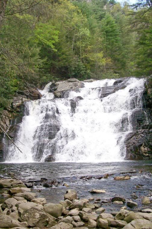 Should be there by early Friday p.m., May 2, 2008.
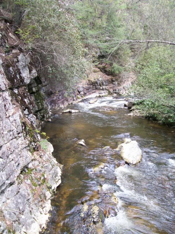
Slack packed nine miles from US Hwy 321 south back to Dennis Cove Road and the Kincora Hostel. The advantages of this short day were:
1. Allowed me to spend the night at Kincora when the outside temp was going to drop into the low 30’s or upper 20’s (brrrr!!)
2. Allowed me to go over a nearly 2,000’ mountain climb carrying 6 lbs instead of 35 lbs.
3. Allowed me to truly enjoy a spectacular waterfall at Laurel Falls. Laurel Falls – you must see the
pictures – it is about 70’ tall and at least as wide. After three days of rain, the falls were nothing but raging white water – beautiful. Like Niagara Falls in miniature. Spent the afternoon, most of it anyway sitting around the hostel smokin’ and jokin’ with the other hikers, catching up on my journaling, and of course eating.Tomorrow morning I launch for Damascus, Virginia. Plan for 2 ½ days. Should be there by early Friday p.m., May 2, 2008.Erwin, TN to Kincora Hostel: Dennis Cove Road, TN
April 25-28, 2008
Total Miles Hiked: 409.3
First day out of Erwin, did 14 miles including the brutal 2,500 foot climb over 3 miles up Roan Mountain: the last 6,000+ ft. mountain until the White’s in New Hampshire. I spent the night at the visitor’s center at Carver’s Gap. It had a good piped spring and a men’s and women’s rest room (chemical toilets). I tented in a fir pine grove. It was the first night on the trail that I spent totally all by myself. It was nice. And, I felt very independent and strong, tenting alone at over 5,500’ of elevation.
2nd day out of Erwin, I did nearly 14 miles hiking across the Roan Mountain Highlands: Round Bald, Jane Bald, Little Hump and Hump Mountain. I would say that this was the most beautiful stretch of the A.T. I’ve hiked so far. Great views, beautiful meadows, lovely farms below in the valleys, horses and cows grazing in the pastures. It was truly breathtaking. I will come back and hike this section again some day.
Spent the night at the Mountain Harbor Hostel. A lovely, lovely hostel in the loft of an old barn at a beautiful farm just 2/10 of a mile off the trail. The hostel owners were not very friendly, but they did shuttle us to a great little steakhouse for an awesome dinner meal and I loved their beautiful farm including the billy goats!!
Third day out of Erwin was a long, wet trudge of more than 18 miles from US Hwy 19E to Moreland Gap Shelter. An unremarkable day – just a long, rainy day.
Fourth day out, made the short 6 miles from Moreland Gap to Dennis Cove Road and the legendary Kincora Hostel. I hung around the shelter this morning until 9:30 a.m. hoping the rain would stop (it did not) then came on down to Kincora, got in about 1:00 p.m. Was able to shower and shave then hop the 2:00 p.m. shuttle into town for supplies and a huge Arby’s lunch. Kincora is run by a retired USAF Colonel and his wife (he retired in 1994). They bought the place 13 years ago specifically to open a hikers hostel. It runs on donations only. No alcohol is permitted and there is no TV and no internet. But, it has the warmest, most friendly, most peaceful vibe of anyplace I’ve stayed on the trail.
I’m going to do a slack-pack out of Kincora tomorrow and send a 2nd night here.
Zero Day in TN
April 24, 2008
Had a peaceful, restful ZERO day at Uncle Johnny's Hostel in Erwin, TN. Going to the Post Office to mail my bounce box to Damascus, VA was my only chore. Otherwise, I chilled: took a nap, laid out in the sun, and tried to even out my hiker tan a bit, soaked my tired feet in the cool water of the Nolichucky River, etc. Oh, and I ate lots and lots of food. That is my 1st priority whenever I go to town: EAT.
I've already lost about 10 lbs. and I've got to be very, very dilligent about gorgining myself whenever I'm off the trail because it's simply not possible for me to carry or eat enough food on the trail to sustain myself. But, I think I've at least stopped losing weight for now -- we'll see.
Anyway, I'm feeling very good about getting started again tomorrow!
Thursday, May 8, 2008
Slack Packing in Tennessee
April 23, 2008
Did a 19.1 mile “slack pack” southbound from Iron Mountain Gap back to Uncle Johnny’s Hostel in Erwin, TN. “Slack Packing” is were someone drives you to a point further north on the A.T. You then walk backward to your starting point, carrying only a daypack with water, food for the day, and minimal essentials (map, first aid kit, etc.). It’s a great way to get in some relatively easy miles, though many “purists” frown on the practice.
I really enjoyed my day of slack-packing and even out performed the 20 and 30 something’s that went with me for the day. We got to the trailhead at 8:35 a.m., and I was the first one back to the hostel at 5:15 p.m. It cost $16 for this service, but was well worth it to me!
Hogback Ridge, NC to Erwin, TN
April 21 & 22, 2008
Did a 10.2 mile day on the 21st with my bud Rain Fly, up and over the big bump of this stretch – Bald Mountain. It was another cold miserable day, but at least it didn’t rain. On April 22nd, the weather improved. We got blue sky in the morning and I decided to stretch my legs and make the fine 16.9 miles all the way into Erwin, Tennessee. I arrived at Uncle Johnny’s Hiker Hostel at 5:30 p.m.- Just enough time for a quick show and still got on the 6:00 p.m. shuttle to dinner at the Mexican restaurant in town. The perfect end to a hard day’s hike.
Did a 10.2 mile day on the 21st with my bud Rain Fly, up and over the big bump of this stretch – Bald Mountain. It was another cold miserable day, but at least it didn’t rain. On April 22nd, the weather improved. We got blue sky in the morning and I decided to stretch my legs and make the fine 16.9 miles all the way into Erwin, Tennessee. I arrived at Uncle Johnny’s Hiker Hostel at 5:30 p.m.- Just enough time for a quick show and still got on the 6:00 p.m. shuttle to dinner at the Mexican restaurant in town. The perfect end to a hard day’s hike.
Flint Mtn. Shelter to Hogback Ridge Shelter, NC
20 April: Total Miles: 311.8
After getting no sleep last night, I only hiked 8.8 miles today to the next shelter. It was another bleak cold (45 degree) rainy day. So, not great loss. Spent the afternoon hanging out with my new buddy Rain Fly from New Orleans.
After getting no sleep last night, I only hiked 8.8 miles today to the next shelter. It was another bleak cold (45 degree) rainy day. So, not great loss. Spent the afternoon hanging out with my new buddy Rain Fly from New Orleans.
Little Laurel Shelter, NC to Flint Mtn Shelter, NC
19 April: Total Miles: 303.0
Hiked 12.7 miles today with Gentleman Jack and Willow. Included going over “The Cliffs”, a rugged area approx. 2 miles long that was supposed to be much like the White Mountains of New Hampshire: very rugged rocks, much hand-over-hand climbing, a lot of bouldering, very tough going.
It was cold and rainy most of the day, including getting drenched the last ½ mile before the shelter. The shelter was full on a rainy night. Willow slept in between Gentleman Jack and me. Usually she tents, but not tonight because of the rain. Well, I snore, so Willow was hitting me in the face every hour (I do not exaggerate) to stop me from snoring. I got like NO SLEEP. It made me very angry – but I let it go, though I decided to break contact with Gentleman Jack and Willow the next day.
It’s one thing to smack someone who snores if he/she gives you permission to do so. But, to just assume the right to hit someone else in the face, and to do so repeatedly is bullshit! If Willow had been a man, there would have been a fistfight in the shelter last night.
(NOTE FROM WIFE: It is true, the Colonel is snores quite horribly. I often sleep in another room with a pillow over my head.)
Spring Mt Shelter to Little Laurel Shelter, NC
18 April: Total Miles: 290.3
Started the day with the intention of going 15.4 miles to Jerry Cabin Shelter and got a reasonably early start at 8:15 a.m. But, that all changed in a good way, when I got to Allen Gap, about 4 miles in at around 10:00 a.m. There at the road crossing was a sign saying “Trail Magic – 350 yards East. Well worth the walk – Don’t Miss It! 6:30 a.m. to 6:30 p.m.”
Well, I followed the signs to a lovely modern log cabin home on the mountainside, ¼ mile down the road. Once there, the owners, (1999 thru hikers) “Hercules” and “F.A.L.” served me and my buddies a 3-course meal of orange juice, Belgian waffles, pork stew, and for dessert, a brownie sundae. Consuming this enormous meal and sharing fellowship took 2 hours of the day.
As a result, I modified my plans and took a short day stopping after only 8.6 miles. But, I’ve been worried about loosing too much weight in recent days, and at least for today, I know I reversed the trend. I’ll log some longer miles tomorrow.
Hot Springs, NC to Spring Mountain Shelter, NC
17 April: Total Miles: 281.7
Hiked 11.0 miles today. Started out alone. Beautiful trail all day starting with about a ½ mile walk along the French Broad Rive, then climbing up the cliffs overlooking Hot Springs. I took some great pictures of both.
Later in the day, I saw many pretty wild flowers along the trail – got some pix of these as well. It got quite warm, perhaps 75 degrees. Then I caught up with my Bear Attack buddies Willow and Gentleman Jack.
Got into camp about 5 p.m. and had a nice relaxing evening. It was by far the warmest night out on the trail. I don’t think it ever went below 50 degrees.
Cold and Miserable

The G-Town Colonel had been complaining about being cold and wet. Here are some pix of what he has been hiking through.


Bear Attack Pix
The mail does not always keep up with actual happenings on the trail. So, here are the pics of the bear attack. Note the paw prints in the snow, the broken tree limb, and the claw marks on the tree trunk.


Tuesday, April 22, 2008
April 16, 2008: Hot Springs, NC
Zero Mile Day!
Had a lovely Zero Day in Hot Springs, NC, population 643 – no kidding. This is a very small town, but it’s very compact, the A.T. literally runs right down Main Street, and it has everything a hiker needs:
Places to stay (albeit not very Fancy, in fact Motel 6 would put them to shame), places to eat (cheap and good), a laundromat, an ice cream shop (yummy!), a Post Office, and a really good outfitter.
It also had some very quaint homes and business which I took pictures of during my self-guided walking tour. I felt really lousy when I woke up this morning, but after a day of relaxation, no hiking, lots of food, I feel much better. I’ll get a fresh start tomorrow morning.
April 15, 2008: Walnut Mountain Shelter to Hot Springs, NC
Miles Hiked: 13.1
Total Miles: 270.7
Well, as one could imagine, it was hard to get going in the morning after no sleep and in 26 degree temperatures. I drank a lukewarm cup of coffee, ate a couple of handfuls of trail mix, and it took what seemed like forever to get packed up and on the trail. I think it was actually about 9:00 a.m. when I started walking.
Another half-marathon day and I got to Hot Springs at almost exactly 5:00 pm. Given that I felt like a sleep-walking zombie with aching feet, not bad. No real highlights to report, but I was so tired, hungry, and hurting, I probably would have overlooked the second coming of Jesus Christ unless it happened 3 feet or less in front of me on the trail.
The first thing on the road when I got to town was a Dollar General Store. Since every article of clothing in my possession was filthy and stinky from 10 days on the trail, I promptly went in the Dollar General, and for $26.00, purchased a t-shirt, socks, underwear, and jeans. I wore my new town clothes to dinner that night and the next day, until I was able to do laundry. I then mailed my new “town clothes” on to my next stop in Erwin, TN where I will use them again.
April 14, 2008: Groundhog Creek Shelter to Walnut Mountain Shelter, NC
Miles Hiked: 13.1
Total Miles: 257.6
A cold, windy, snowy, late winter day today. L long half-marathon trudge.
It was necessary to do this long day in order to make it to Hot Springs the following day. And, I wanted that quite badly have not been to town for nearly 10 days now.
The high point of the day, literally and figuratively, was Max Patch. Max Patch is a huge bald of over 300 acres atop a 4,300 foot mountain. Even in the snow, the views were stunning.
This evening at Walnut Mountain was the night of the Famed “Bear Attack”. But I have already posted the complete details of this horrific event. So, I will not repeat myself here.
April 13, 2008: Standing Bear Farm, Hartford, TN to Groundhog Creek Shelter, TN
Miles Hiked: 7.2
Total Miles: 244.5
Had a really good nights sleep in the bunkhouse at the Standing Bear Farm. Had thought about taking a zero day, but felt so good that I decided instead to take a late start from the Farm (left about 11:00 a.m.) and just hike a few miles.
So, I just went 7.2 miles to the first shelter at Ground Hog Creek. There I met up with Willow, Gentleman Jack, and Southpaw, who I would hike with for the next several days.
It was the usual tough uphill slug out of a low re-supply point – about a 2,5000 foot uphill climb for the day. No rain or snow, just kind of gray today.
This evening Jack and Willow tented leaving only me and Southpaw in the shelter. Turns out he’s a retired Navy E8, about 6 or 7 years older than me. Just old enough to have served in Vietnam, on the river boats no less: ala “Apocalypse Now!”, and is still somewhat haunted by the experience. It was a good man-to-man, heart-to-heart talk.
April 12, 2008: Tri Corner Knob Shelter GSMNP, NC to Standing Bear Farm, TN
Miles Hiked: 18.1
Total Miles: 237.3
Wow, hiked 18.1 miles today all the way out of the GSMNP and to the Standing Bear Farm Hikers Hostel.
The day started out with rain and thunderstorms while I was making breakfast in the shelter but it never actually rained on me out on the trail as I hiked. In fact, by mid afternoon, the sun was shining and the temperature was in the mid-70’s as I was dropping elevation rapidly.
As I left the park, I saw perhaps the most beautiful area I’ve seen so far, the crossing of the Pigeon River. Beautiful streams, spring in full bloom, flowers everywhere, water falls, butterflies. It was gorgeous. The Lord and the Lady truly live here! I hope my pictures come out.
I slept in this morning at the farm. What a neat rustic place! Got a hot shower – old school style – last night. Did not get to wash clothes, but only 2 ½ days from Hot Springs, so I’ll survive.
Expecting rain and snow for the next two days, then warmer weather.
Monday, April 21, 2008
April 11, 2008: Ice Water Spring Shelter to Tri-Corner Knob Shelter
Miles Hiked: 12.6
Total Miles: 219.2
Did 12.6 miles today including going over Mt. Sequoyah, 6,069 feet and Mt. Chapman at 6,417 feet. It was foggy, misty, and very windy all day. I really thought it would rain, but the my weather God was with me for the 5th straight day. I got thru my hike, into camp, set up, ate dinner, and settled in to bed for the night before the rain finally started.
I really do believe I’ve found my trail legs here in the Smokies.
Tonight I’m sharing the shelter with two other thru-hikers and four section hikers. We’ve got a fire going in the fireplace and it’s really quite cozy. The word is that the temperature is supposed to drop dramatically tonight. Maybe into the 20’s. So I’m bundling up.
It’s only 16 miles out of the park and only 18 miles to the Standing Bear Farm Hostel. I’m going to go for it tomorrow, I do believe. It’s mostly downhill!
And a warm bed and shower await me at the end if I make it!!
April 10, 2008: Double Spring Gap Shelter to Ice Water Spring Shelter
Great Smoky Mountain National Park (GSMNP) NC
Daily Miles: 13.8
Total Miles 206.6
I believe I earned my Hiker boots today. Several firsts: Longest day so far with 14 miles. Hiked over the highest point on the entire AT, Clingman’s Dome at 6,643 feet. Have now hiked more than 200 miles total. And now have less than 2,000 miles left to go to Katahdin. So, I am a real thru-hiker now! And I feel pretty good at the end of the day to boot!
It was another beautiful, warm sunny day in the Smokies. Amazing – 4th day in a row.
Made camp tonight with two very nice ladies in their 50’s who are section hikers. They are slowly but surely section hiking all of the AT. They shared stores of various hiker characters they’ve met over the years. It was quite entertaining!
In addition to climbing over the Dome, a high point of the day, was going thru Newfound Gap and tourist-watching for a few minutes. It was also fun to reflect back on the great times my wife and I have had hiking in the GSMNP in years past. I really wish she could be here hiking with me now. Oh well, she is always with me in my heart.
April 9, 2008: Derrick’s Knob shelter to Double Spring Gap Shelter
Great Smoky Mountain National Park (GSMNP) NC
Daily Miles: 6.3
Total Miles: 192.8
Short day today. Given the spacing of the shelters in the GSMNP, and hikers must stay at shelters, my alternative was to go 14 miles. I felt pretty worn out from the previous two days of 12 miles each and I just did not think I had a 14 miler in me yet, especially considering that it would have included summitting Clingman’s Dome at 6,620 feet, the tallest peak on the entire Appalachian Trail. I opted to take a short day today and rest up a bit before taking on Clingman’s tomorrow morning.
I also wanted to rest my right knee a bit. It has been bothering me a little ever since the NOC descent. I asked some other hikers about this and they suggested I start using two poles instead of just one. I’ll give that a try as soon as I can, though won’t be till Hot Springs in about a week or so.
Anyway, got into camp at about 1:30 p.m. today – super early for me. It was more like 6:30 p.m. the previous two days. Felt great to just relax, catch up on my journal, etc.
April 8, 2008: Mollie’s Ridge Shelter to Derrick’s Knob Shelter
Great Smoky Mountain National Park (GSMNP) NC
Daily Miles: 12.6
Total Miles: 186.5
Elevation gain today at the end of the day was only 300 feet, but it was a very tough day with several 700’-1000’ elevation gains and losses; lots of steep up’s and down’s.
There is awesomely beautiful scenery along the way. I took many pictures that I hope come out. Again today, it was sunny and unseasonably warm – More like when my wife and I hiked here last August than what I expected in early April. Bit, I’ll gladly take this over freezing in the rain or the snow.
Physically, it is still very challenging. Not impossible – but tough, especially carrying a heavy load of 7 days, plus 1 spare day of supplies.
April 7, 2008: Fontana Village (Dam) to Mollie’s Ridge Shelter
Great Smoky Mountain National Park (GSMNP) NC
Daily Miles: 11.0
Total Miles: 173.9
Hiked the blue blaze around the Dam because it is under construction. So, hikers were not allowed to walk across the top of the Dam. It was all uphill, today, of course, with a total elevation gain of 2,870 feet.
It was really warm and sunny today. I’d prayed to my weather God for good weather in the Smokies, and I got it, at least for the first day. I bet it was a record high temp, or near to it. My thermometer read in the upper 70’s.
I think I took a wrong turn on the blue blaze around the Dam and as a result, I ended up right at the very north edge of the Dam and the very southern entrance of the Park, which was cool. I took lots of pictures today.
Wednesday, April 16, 2008
Bear Attack !!!
This IS a true story!
On Monday, April 14, 2008, I hiked approx 13.5 miles to the Walnut Mountain Shelter which is located on the North Carolina / Tennessee border north of the Great Smokey Mountain National Park and about 14 miles south (via the A.T.) of Hot Springs, North Carolina. It was lightly snowing all day, windy, and cold. I was hiking with three buddies of a few years older in age than myself Miss Willow, Gentleman Jack, and Southpaw. We got to the shelter at about 6 pm. It was getting even colder, even windier, and even snowier. There was an ominous note pinned to the shelter wall. It warned us of an aggressive bear and told us to hang our food bags high and well. We looked around and found the highest, strongest, tree branch we could and hung our bags after dinner. Then we quickly got into our sleeping bags and tried to warm ourselves against the bitter cold night.
It was not long before the attack began. At about 8:40 pm we heard the first rustling sounds outside the shelter. Shining our headlamps revealed a small bear. Bear! Bear! Get Out, Bear! We yelled and flashed our lamps and it ran off. Whew, we were safe - we thought. Back in our bags with one eye and one ear open. Then about 10:00 pm we heard more rustling outside, more scratching and clawing. Quickly followed by a loud cracking noise and a great crash. We flashed our lamps and saw that the entire tree branch had broken off and all four food bags were on the ground! Somehow the bear had climbed the tree and its weight had broken the branch.
We all four got out of our bags, went outside in our crocs, freezing in our nightclothes, and huddled trying to decide what to do. Throw all our food over the ravine and save only the bags themselves? Throw some food down the ravine and try to save the rest? Hike out now in a night blizzard (more than 10 miles to the next shelter)? Ultimately we decided that if we gave up our food bags the bears might next come after our packs in the shelter, and then after us. So we decided our best defense was to rehang the bags and try to defend them.
So we found another tree, albeit, much smaller, and lower to the ground, and rehung the bags. By 11 pm we were back in our bags. This tree was directly in front of the shelter, perhaps 15 feet from where we were sleeping and gave us a birds eye view if the bear came back. Well, at about 12:40 am the bear was back! Again we hooted, hollered and threw rocks and again it ran off. But then, at about 2:30 am an ENORMOUS bear lumbered up to the tree, rose up on its back legs and started to climb the tree. This bear was at least 5 feet tall and must have weighed at least 200 pounds. After the fact we figured the little bear must have been the cub and the big bear the mama. An it must have been mama bear that broke the limb of the first tree. Well, we screamed and hollered and threw rocks and the bear just looked at us! Finally, Gentleman Jack hit the bear with a rock and it left. The final bear attack came at about 3:10 am. We were not sure which bear it was at this time. Needless to say, little or no sleep was had that night and we were all grateful when daylight came at about 6:30 am or so.
When daylight did come and we felt safe enough to venture out of the shelter we found that the bears had in fact ripped the bottom out of one of the four food bags (Willow's). So the final score: Humans 3, Bears 1. While no one got pictures of the bears attacking that night, we all took photos the next morning of the claw marks in the tree, of the broken tree limb, and of the massive paw prints in the snow around the shelter. These pix will be sent with my next batch of photos home.
This is a night I will never forget.
the G'Town Colonel
Saturday, April 12, 2008
Out of the Smokies
I was out in the pasture with the animals when the G-Town Colonel called at 6:30 p.m. He is out of the Great Smoky Mountain National Park (alive) and is somewhere in Tennesee. He received his re=supply package, so I assume he made it to the Post Office today (Saturday) before it closed. The cell phone reception was really bad; he hopes to call again collect.
Friday, April 11, 2008
Subscribe to:
Posts (Atom)